
LITTLE YABBA CIRCUIT
Charlie Moreland Day-Use Area
1.8km return (allow 45 minutes) Grade 3 The same start and finish point, but the traveller doesn’t return along the same path. The circuit starts from the Charlie Moreland day-use area, where you can wade across Little Yabba Creek to explore hoop pine plantation and riparian rainforest. This is a fabulous area for bird watching. Creek banks lined with riparian rainforest provide the perfect habitat for local birdlife. Track-side signs are there to help identify these birds. Discover towering hoop pines before enjoying a cool swim in one of the waterholes in Little Yabba Creek. From Kenilworth, follow Maleny–Kenilworth Road for 7km and turn right onto Sunday Creek Road. Drive 5km to the day-use area. Wheelchair access – NO wheelchair-accessible facilities. LINK TO DES MAP & MORE INFORMATION HERE |

PICABEEN CIRCUIT
Charlie Moreland Cay-Use Area
3.5km return (allow 2 hours) Grade 3 An extension of the Little Yabba Circuit, this walk explores hoop pine plantation, riparian rainforest and a piccabeen palm grove. Admire the tall stands of native hoop pines originally planted in the mid-1900s by Charlie Moreland’s forest ranger crew. Piccabeen circuit is in Imbil State Forest, about 150km north of Brisbane or 60km south of Gympie. The circuit is an extension of Little Yabba circuit, which is accessed from Charlie Moreland day-use area. From Kenilworth, drive 7km south on the Maleny-Kenilworth road to the Sunday Creek Road intersection. Drive 5km along Sunday Creek Road to the Charlie Moreland camping and day-use areas. Wheelchair access – NO wheelchair-accessible facilities. LINK TO DES MAP & MORE INFORMATION HERE |

MT ALLEN SHARED TRAIL
Charlie Moreland Day-Use Area
8.8km return (Allow 4hrs walking time) Grade 4 This challenging hike is a shared trail with walkers, cyclists and horse riders. The final 300m to the Mt Allen firetower, however, is only for walkers, so leave your bike or horse at the hitching rail. You’ll pass through hoop-pine plantations as you head upwards to Mount Allan. Breathtaking scenery surrounds you and photographers will love the panoramas. Mount Allan shared trail is in Imbil State Forest on the Sunshine Coast, about 150km north of Brisbane or 60km south of Gympie. This trail is accessed from Charlie Moreland day-use area. From Kenilworth, follow Maleny–Kenilworth Road for 17km and turn right onto Sunday Creek Road. Drive 5km to the day-use area. Wheelchair access – NO wheelchair-accessible facilities LINK TO DES MAP & MORE INFORMATION HERE |

CONONDALE GREAT WALK
Bolumba Creek Day-Use-Area
56KM – 3 – 4 day walk – Grade 4 walk A range of walking experiences are offered within this great walk—from short strolls to the challenging four day, 56km, full circuit walk. Whichever you choose—the Conondale Range Great Walk offers an adventure to remember! Day 1: Booloumba Creek section – 11k Day 2: Mount Gerald – Peters Creek section: 17k Day 3: Peters Creek – Summer Falls section: 15.2k Day 4: Mount Allan – Booloumba Creek section: 12k From Kenilworth travel south on the Maleny Kenilworth Road for 7km before turning right onto Booloumba Creek Road. Travel a further 5km along this road to the entrance of the park. From here on, the road is unsealed and you will need a High Clearance 4WD as there a number of creek crossings. After 1km you will reach the Day Use Area on the right, where you can park. LINK TO AUSSIE BUSHWALKING SITE |
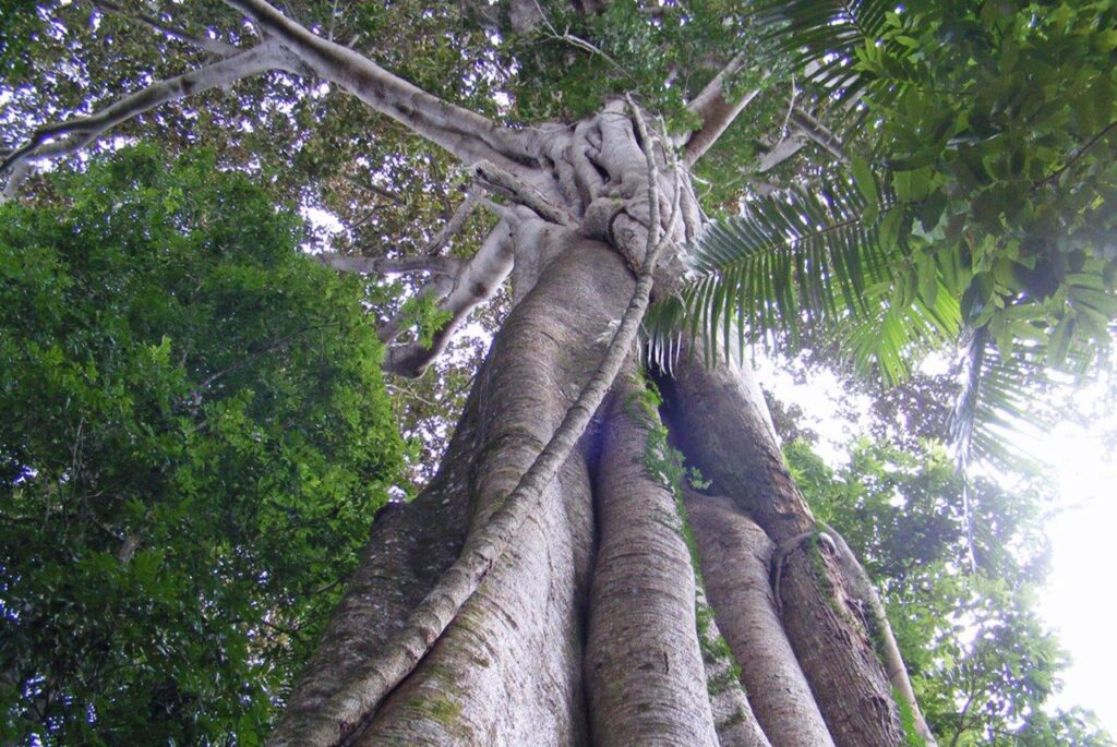
FIG TREE WALK
Little Yabba Creek
780m (allow 45 minutes) Grade 1 Stand in awe beneath magnificent, 150 year-old Moreton Bay fig tree and take in the towering canopy of piccabeen palms, flooded gums and white cedars. Utilise the wheelchair – accessible boardwalk to explore this walk. Lister for the multitude of birds always present in the forest. The circuit starts from the day-use area at Little Yabba Creek on the Maleny-Kenilworth road. You then walk 150m on the footpath beside the Kenilworth-Maleny Road to the start of the circuit track. Please be careful as the road can be busy. To reach Little Yabba Creek day-use area, from Kenilworth drive 7km south on the Maleny–Kenilworth Road, 150m past the intersection with Sunday Creek road. Accessible by 2WD conventional vehicle Wheelchair access – YES – This track is wheelchair accessible -may require assistance. LINK TO DES MAP & MORE INFORMATION HERE |

AMAMOOR CREEK HIKING TRAIL
Amamoor Creek Camping Area
Walk 2.5km circuit (Allow 2 hr 30min) Grade 4 walking track A hiking trail through open, eucalypt forest and through forest with an interesting mix of rainforest plants. The trail starts at teh Amamoor Creek Camping Area and heads East then branches North to start the loop trail. The trail finshes in the same locationb but takes the walker on a different return path. There are some challenging sections and a moderate fitness level is required. Amamoor Creek Camping Area lies aproximately 16 km from Amamoor township and 12km along Amamoor Creek Road from the park entrance. You travel past the Amama Day-Use Area and Cedar Grove Camping Area on the way. Caution is required in wet weather, the creek can rise quickly during heavy rainfall cutting off access. Accessible by conventional vehicle. LINK TO DES MAP & MORE INFORMATION |

AMAMA WALK
Amama Day-Use Area
1.5km circuit (allow 40 mins) Grade 4 walking track A challenging short walk starts across the road from the Amama Day-Use area approximately 1km inside the park entrance. It runs beside Amamoor Creek winds its way through picturesque rainforest past the stunning ‘The Cascades’ waterfall. Do the loop through the Fig Tree Circuit on the homeward bound section. Take a swim to cool off and listen for the birds while you rest. Early morning or late afternoon, you may see a platypus in Amamoor Creek, if all is quiet. Keep an eye out for telltale bubbles on the water’s surface. From the Bruce Highway, take exit 253 onto Mary Valley Link Road, 20km south of Gympie. Turn right onto Mary Valley Road, then left onto Blackgate Road, following the signs to Amamoor township. Turn right onto Busby Street, which becomes Amamoor Creek Road. Follow Amamoor Creek Road for 4km to the entrance of Amamoor State Forest. Wheelchair access – NO wheelchair-accessible facilities. LINK TO DES MAP |

CEDAR GROVE HIKING TRAIL
Cedar Grove – Amamoor State Forest
4.6km circuit (allow 4 hours) Grade 4 walking track This is a steep but beautiful scenic hiking trail and is a circuit track that branches off the Rainforest walk from the Cedar Grove camping area. The first kilometer is steep, climbing over 160m in elevation. You may like to cool off in the natural waterholes at the start of the track before you begin your walk. After making your way through the rainforest, you then enter large open eucalyptus forests as you climb, then pass through native hoop pine plantations before rejoining the Rainforest Walk to complete the circuit. The Cedar Grove hiking trail is in Amamoor State Forest along the Amamoor Creek Road with the walk beginning near the Cedar Grove camping area, about 8km along Amamoor Creek Road from the park entrance. From the Bruce Highway, take exit 253 onto Mary Valley Link Road, 20km south of Gympie. Turn right onto Mary Valley Road, then left onto Blackgate Road, following the signs to Amamoor township. Turn right onto Busby Street, which becomes Amamoor Creek Road. Follow Amamoor Creek Road for 4km to the entrance of Amamoor State Forest. Caution is required in wet weather. Wheelchair access – NO wheelchair-accessible facilities. LINK TO DES MAP & MORE INFORMATION HERE |

CEDAR GROVE RAINFOREST WALK
Cedar Grove – Amamaoor State Forest
1km Circuit (allow 30 minutes) Grade 3 track This rainforest circuit walk starts at Cedar Grove camping area at the very popular swimming hole. From the southern side of the camping area you cross the footbridge to enter a subtropical rainforest consisting of large blue gums, tall forest oaks and a stunning piccabeen palm grove. The circuit follows Amamoor Creek around the camp site for a short circuit walk. A photographer’s paradise awaits as you walk through the forest, with fungi, trees, twisting vies and a marvellous canopy. From the creek bank you can see native fish and if you are quiet, a platypus. From the Bruce Highway, take exit 253 onto Mary Valley Link Road, 20km south of Gympie.Turn right onto Mary Valley Road, then left onto Blackgate Road, following the signs to Amamoor township. Turn right onto Busby Street, which becomes Amamoor Creek Road. Follow Amamoor Creek Road for 4km to the entrance of Amamoor State Forest. Caution is required in wet weather. The creek can rise quickly during heavy rainfall, cutting off access. Wheelchair access – NO wheelchair-accessible facilities. LINK TO DES MAP & MORE INFORMATION HERE |

OLLY DWYER TIMERMAN'S WALK
Short Stroll in Imbil Village
You will find the Timberman’s Walk in the centre of Imbil where it meanders along a timber walk way underneath giant Jacarandas, down towards Yabba Creek. Along the way you can pause to read plaques with historical information relating to the timber industry in the Mary Valley. |

MARY VALLEY RAIL TRAIL
Imbil to Brooloo and return
4.5km one-way return trail An easy 4.5km one-way return trail between Imbil and Brooloo, this is a shared trail for walkers, cyclists, dog walkers, horse riders. It is an easily accessible and popular trail for locals and visitors. The once used Mary Valley Railway line between Imbil and Brooloo has been restored to a trail which passes through State Forestry and Bellbird Habitat. TELL ME MORE… |

LOOKING FOR A TRAIL?
Find hundreds of tried and tested local walking trails via WIKILOC. Hikers can download the app and record their trail then upload to the program and share with the world. A safe way to check trails first before heading out and a great way to play your walking adventure in Mary Valley Country.
READ MORE ABOUT WIKILOC HERE |

|
2023 Proudly brought to you by the Mary Valley Chamber of Commerce
Supporting and promoting Mary Valley Business |